
The 1917 completion of the Lake Washington Ship Canal and the Montlake Cut dramatically lowered Lake Washington. Shorelines were created; the Black River disappeared; routinely flooded places became dry and dry places, wet. Over the last year, I began researching this transformation, fascinated by the impact of man on the landscape. Like a palimpsest, the lake and wetlands were partially removed to make room for another text. Today, wetlands are reclaiming some of those areas and returning them to their earlier form. In others, man's encroachment remains.
This is my attempt to reveal the illusive story of this intervention: my research, and a selection of pinhole photographs and soundscapes I composed in response to this altered landscape.
This is my attempt to reveal the illusive story of this intervention: my research, and a selection of pinhole photographs and soundscapes I composed in response to this altered landscape.

TASK
FIND OVERLAY MAP
FIND OVERLAY MAP
- visit Seattle Public Library. Review Washington State history files. Find no map. Referred to UW.
- visit University of Washington Special Collection Map Room. Find maps pre1911 and post 1916. None have a street overlay. Referred to the Ballard Locks information desk.
- contact Locks referred to Museum of History and Industry (Mohai)
- visit Mohai library and archives. Hit pay dirt. Find map prepared by USGS in 1983 that shows overlay of streets and shoreline, pre and post 1916. However, map cannot leave the premises. Take copious notes.
- contact USGS and inquire about map. No response.
- contact USGS again several months later. Referred to USGS archives. Diane Garcia says she will try to get a copy for me. No luck. Refers me to Washington Geology Library.
- Lee Walking of Washington Geology Library has a copy but can't release it. Promises to make me a computer scan.
- It arrives with all the documentation.

TASK
FIND OUT WHEN, WHO, WHAT/WHY*
Short Version
1861-1917 (56 years) Begun by Harvey Pike; completed by Hiram Chittenden; Commerce (aka Greed).
Long Version
FIND OUT WHEN, WHO, WHAT/WHY*
Short Version
1861-1917 (56 years) Begun by Harvey Pike; completed by Hiram Chittenden; Commerce (aka Greed).
Long Version
- 1861 Harvey Pike obtains deed to 200' wide strip for a canal crossing. Goal is to transport coal from Newcastle to Puget Sound.
- 1871 Pike deeds property to Lake Washington Canal Company. Petitions Congress for title to submerged lands that might be reclaimed if canal is built.
- 1871 Army Corps of Engineers evaluates canal potential for fresh water storage of Naval Ships in Lake Washington but doesn't act.
- 1883 David Denny, Thomas Burke, F.H. Whitworth, H.B. Bagley, C.C. Phinney form Lake Washington Improvement Company to dig the Montlake Cut to transport logs but they abandon job.
- 1883-85 Lake Washington Improvement Company hires Wa Chong and 25 Chinese laborers. They excavate .2 miles south of current Cut.
- 1903 Army Corps of Engineers decides demands of commerce don't justify the expense.
- 1903 Break in earth dam at outlet of Lake Union allows saltwater to infiltrate the Lake and threaten fresh water. Lake Union drains down to within a foot or two of high water in Puget Sound.
- 1906 Congress authorizes James Moore to build Canal. Moore was a contractor for the Denny Regrade. He asks King County for $.5 million.
- 1907 State Supreme Court rules against the legality of issuing Bonds for this purpose.
- 1907 Moore assigns rights to Lake Washington Canal Company.
- 1907 Major Hiram Chittenden gets Congressional appropriation for land survey to study an alternate route that would take the canal through UW.
- 1907 Ballard millmen organize to halt construction.
- 1909 Washington State Legislature appropriates $250,000.
- 1910 King County votes bond issue of $740,000; Congress authorizes the remaining in Federal money.
- 1911 Chittenden oversees groundbreaking and construction. 4,000,000 cubic yards of dirt are dredged from the Ship Canal. 230,000 yards of concrete are poured to form the Locks.
- 1916 The Locks and Montlake Cut are completed, Between August 25 and October 21, the overall Lake drops by 8'9". 2506 acres of land are "reclaimed".
- 1917 Ships first pass from Puget Sound through Lake Union to Lake Washington. Grand opening celebrations are held on July 4.
- 1917 Hiram Chittenden dies October 9.


TASK
FIND THE BLACK RIVER
All sites were easy to find except the Black River. You try to find a river that has disappeared...
FIND THE BLACK RIVER
All sites were easy to find except the Black River. You try to find a river that has disappeared...
- Called Liz Stuart, Renton Historical Museum. Refers me to Leslie Betlach at Renton Parks.
- Leslie Betlach refers me to Ron Straka, at Renton Water Department.
- Ron Straka refers me to Ryan Zulaf at Renton Airport.
- Ryan Zulaf tells me to go to Safeway and Fred Meyer parking lots because they were built on fill. Also tells me that there are "visible remnants" of the Black River at the Renton Airport. I go to the aiport but can find no remnants. Enter a private trailer park to get a better look. Confronted by a woman for trespassing. I explain what I am doing and she tells me her son is a screenwriter. "Happy to help," she says. She sends me to the naturalized area next to the wastewater treatment plant. She says there is a heron rookery there and she thinks it is a remnant of the river. Her last words to me. "Not sure I would go there alone."
- I park my car. It looks like the kind of place where ax murderers may be lurking. I call home. "If I don't call you back in an hour, here's where you should send out the search party."
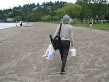
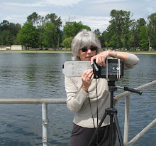
- I've got my pinhole camera, tripod, film box, bucket of sodium sulfide, trash bag, timer, light meter, digital recorder, headphones, microphone. I plunge into the woods and can hear a stream.
- As I trudge along the stream bed, I eventually find a sign saying "Black River Riparian Forest" along with a notation of a watershed conservation group and phone number. Doris Yipez answers my call. She tells me that what is left of the river serves as the stream bed for Springbrook Creek. This mysterious place is now home to 150 nesting pairs of heron.

Subscribe to:
Posts (Atom)


